
Between late June and mid-July 2022, the Democratic People's Republic of Korea (DPRK) experienced heavy rainfall and flooding after having suffered severe drought from April through June 2022. The southwestern region - an important agricultural production base for the country - was significantly affected. The extreme weather conditions are expected to impose significant economic and social costs on the DPRK. On the basis of available open source information, ONN has identified locations of possible damage and assessed the scope of such damage.
This paper presents a summary of ONN's findings.
Key Findings
From 25 to 30 June and around 7 and 13 July 2022, multiple cities and counties in the southern and western provinces of the Democratic People's Republic of Korea (DPRK) were affected by heavy rainfall which recorded precipitation levels that far exceeded historical averages. As a result, the heavy rainfall reportedly caused flooding that affected town centres, agricultural fields, roads, and bridges in the region.
Analysis of available open source information, including that from satellite imagery and precipitation data from monitoring stations in the DPRK, has found that flooding also occurred in areas not reported by DPRK media. This unreported flooding may have caused significant disruption to the DPRK's agricultural production. According to a DPRK media report, the national average precipitation level nearly reached the record high precipitation levels of 2013. While further assessment is essential, the damage from the heavy rainfall and flooding in June and July 2022 to agricultural fields could be more severe than that in August 2021.
Key findings are summarized below:
-
Satellite imagery analysis has confirmed DPRK's reports about flooding of agricultural fields, roads, and bridges in North Pyongan, South Pyongan, North Hwanghae, and South Hwanghae provinces. While not mentioned in DPRK media, Kangwon and South Hamgyong provinces were also adversely affected by the flooding.
-
While available satellite images were limited, as the weather in the DPRK was mostly cloudy, ONN's analysis has also confirmed that, at a minimum, approximately 6.05 km2 of agricultural fields were affected across North Pyongan, South Pyongan, North Hwanghae, South Hwanghae, Kangwon, and South Hamgyong provinces. This is larger than the approximately 3.7 km2 affected areas in various parts of the DPRK that were identified by ONN following the August 2021 heavy rainfall.[1] While the full extent of the damage from the heavy rainfall in 2022 is not clear, the scale of the affected areas identified in this report suggests a significant impact on current crop growth and autumn harvest in the coming weeks.
-
No clear signs of damage to industrial or societal infrastructure or buildings could be observed in available satellite images. Water levels were observed as having risen significantly at dams and water reservoirs, recovering from the reduced water levels caused by the drought during the spring of 2022. Although there were observed signs of overflow at some of the reservoirs, no visible signs of damage to these dams or reservoirs were apparent.
-
At the Punggye-ri nuclear test site, external observers identified a landslide after the heavy rainfall which appeared to have interrupted road construction work near two of the nuclear test tunnels.[2] Thus far, this is the only physical damage at the military-related sites that is visible in available satellite images.
-
The precipitation levels in late June and July 2022 reported by monitoring stations in the DPRK indicate several unusual spikes that are many times higher than historical averages, particularly on and around 25 to 30 June and 7 and 13 July 2022. According to Korea Central Television (KCTV), the national average precipitation level between late June and mid-July 2022 showed a 230% increase from the historical average, nearly reaching the record high precipitation levels of 2013. As of 31 July 2022, the end of the period under review in this report, the monsoon season had not yet finished in the DPRK. A prolonged period of heavy rainfall and flooding could further weaken the soil, which could cause further damage to agricultural fields and increase the risk of damage to infrastructure and buildings.
Introduction
On 30 June 2022, KCTV reported that multiple regions in North Hwanghae and South Pyongan provinces, including the cities of Pyongyang, Nampo, Sariwon, and Kaesong, had experienced heavy rainfall with precipitation levels significantly greater than historical average. Reportedly, roads and agricultural fields in these provinces were damaged.[3] This was followed by heavy rainfall on 7 July 2022 in North Pyongan province, including the city of Sinuiju, and other heavy rainfall around 13 July 2022 that affected South Hwanghae, North Hwanghae, and North Pyongan provinces, including the city of Haeju, which also appears to have caused damage to agricultural fields.
Figure 1. Measured flooding of agricultural areas (km²) 15 June - 15 July. Shapefile source: UN Office for the Coordination of Humanitarian Affairs
Precipitation in June and July 2022
Throughout April and May 2022, the DPRK experienced widespread drought. The southern provinces were the most significantly affected, including North Hwanghae and South Pyongan provinces, where rainfall was consistently less than 60% of the historical average for the same months. In several parts of North Hwanghae province, including the city of Kaesong, precipitation levels were below 40% of the historical average for the month of May. On 25 June 2022, heavy rainfall resulted in a sudden spike in precipitation levels across North Hwanghae and South Pyongan provinces.
All provinces in the DPRK recorded precipitation spikes several times higher than the historical average during late June to mid-July 2022. Notably, the precipitation levels from 15 June to 15 July 2022 reported by 13 DPRK monitoring stations[4] in North Pyongan, South Pyongan, North Hwanghae, and South Hwanghae provinces recorded unusual spikes far higher than historical average,[5] in particular on 25 to 30 June and around 7 and 13 July 2022 (Figure 2).
In addition, Kangwon province recorded precipitation levels far above 100 mm, and flooding of some agricultural fields, not reported in DPRK media, was visible in available satellite imagery. Two areas in South Hamgyong province recorded precipitation levels below 100 mm, but were also found to have flooded agricultural fields, which is visible in available satellite imagery.[6] The nationwide precipitation levels were also far above the levels recorded during the same period in 2021. In 2020, similar precipitation spikes occurred but were less frequent and affected a smaller area.
Figure 2. Precipitation level in major cities in the DPRK, 15 June to 15 July 2022. Source: Korea Meteorological Association & World Meteorological Organisation[7]
Damage Reported by DPRK Media
On 30 June and 4, 7 and 13 July 2022, KCTV aired news reports on the impact of the heavy rainfall and flooding, featuring flooded agricultural fields and moderate visible damage to these agricultural fields. Reportedly, between 26 and 30 June 2022, South Pyongan province recorded the highest cumulative precipitation rate of 355mm, which was closely followed by Nampo (352 mm) and Pyongyang (340 mm) for the same period (Figure 3, 4).[8]

Figure 3. Average precipitation by province, 26 to 30 June 2022. Korean text below numbers reads: "Pyongyang, North Pyongan province, South Pyongan province, North Hwanghae province, South Hwanghae province, Chagang province, Kangwon province, North Hamgyong province, South Hamgyong province, Ryanggang province, Nampo, Rason, Kaesong". Source: KCTV[9]
On 7 July 2022, heavy rainfall flooded roads and town streets and damaged agricultural fields in eight counties across North Pyongan province. Cholsan county recorded the highest precipitation levels of 143.8 mm in the first 13 hours of the day, closely followed by Kusong county which recorded precipitation levels of 141 mm during the same time.[10]
On 13 July 2022, heavy rainfall and flooding affected Paechon county and other counties and towns in South Hwanghae province, the town of Chongju in North Pyongan province, and Kaesong city.[11] Among those affected counties and towns, Paechon county reported the highest precipitation levels of 198 mm in just 17 hours. On the same day, Kaesong city received further heavy rainfall of over 170 mm, within two weeks from the previous heavy rainfall that ended on 30 June 2022, which flooded agricultural fields, roads, and city streets (Figure 4).[12]
Figure 4. Flooding and damage after rainfall in late June 2022.Source: KCTV[13]
Reportedly, the countrywide precipitation level from late June to mid-July was over double that of an average year and had nearly reached the levels of the record year of 2013 (Figure 5).[15]
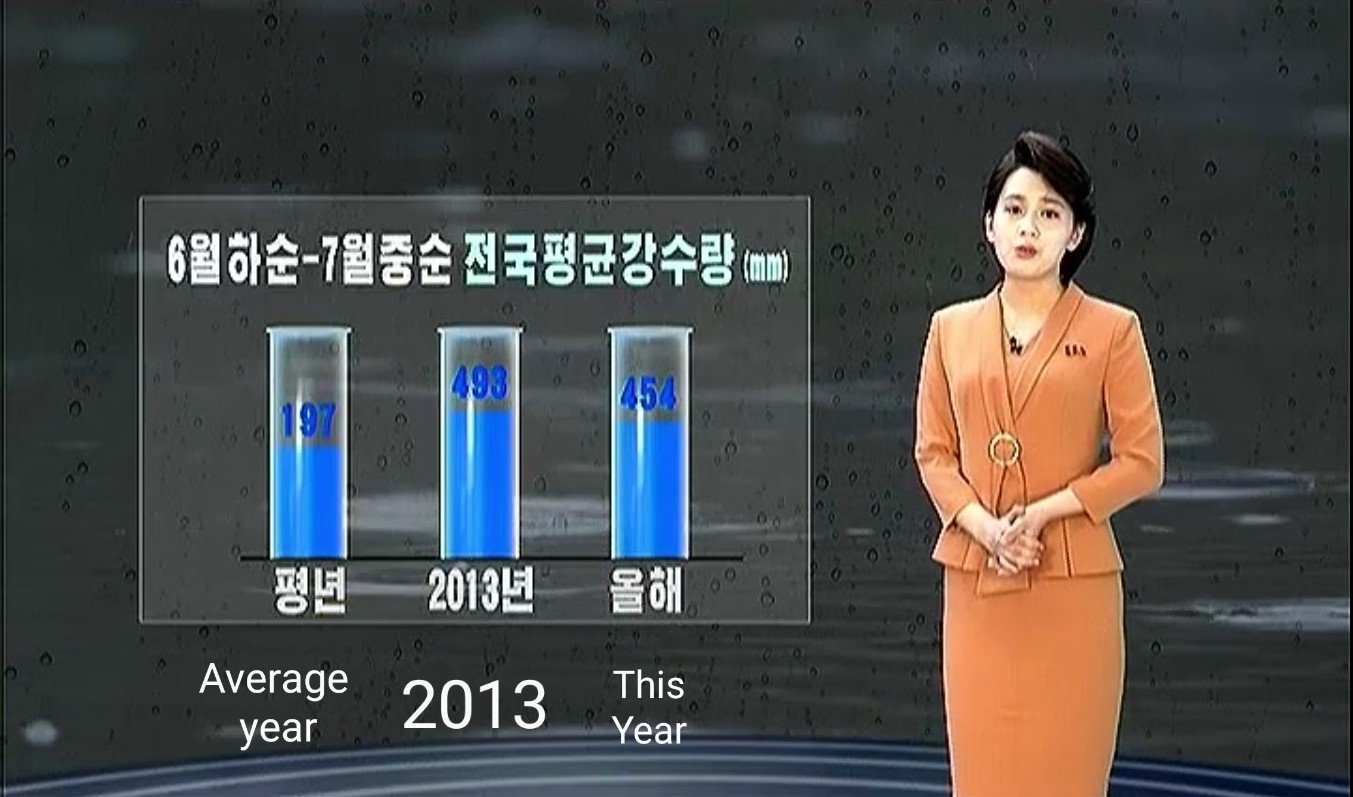
Figure 5. National average precipitation late June to mid-July 2022 was 454 mm in 2022 and 493 mm in 2013. Historical average for the same period was 197 mm. Source: KCTV (English translation on image: ONN)[16]
The video footage from KCTV did not show any indication of severely damaged buildings or infrastructure, with the exception of a broken road (Figure 4). Nevertheless, through DPRK media, the country's leadership has continuously urged its people and local authorities to remain vigilant and prepare for coming heavy rainfall and flooding, indicating the significance of the prevention of damage from heavy rainfall and flooding in the country's public policy.[17]
Assessment of Damage
Satellite imagery analysis has confirmed KCTV's reports on flooding of agricultural fields, roads and bridges in North Pyongan, South Pyongan, North Hwanghae and South Hwanghae provinces. The analysis has also revealed that Kangwon and South Hamgyong provinces were affected by the flooding, but this was not reported by DPRK media.
South Pyongan Province
DPRK media frequently referred to South Pyongan province as one of the areas affected by heavy rainfall and flooding. The satellite images from 5 July 2022 show flooding of agricultural fields (approximately 0.13 km2 and 0.2 km2) following the rainfall between 25 and 30 June 2022 (Figures 7, 8).
Figure 6. Flooding of agricultural fields in Taedong county, South Pyongan province. Image: © 2022 Planet Labs. All rights reserved. Reprinted by permission
Figure 7. Flooding of agricultural fields near Chemoe, South Pyongan province. As of 5 July 2022, water level of the reservoir returned to pre-spring drought level. Image: © 2022 Planet Labs. All rights reserved. Reprinted by permission
North Pyongan Province
After the rainfall on 13 July 2022, the flooding of agricultural fields (approximately 0.85 km2) was clearly visible on the satellite image from 14 July 2022 (Figures 9, 10).
Figure 8. Flooding of agricultural fields near Chongju, North Pyongan province. Image: © 2022 Planet Labs. All rights reserved. Reprinted by permission
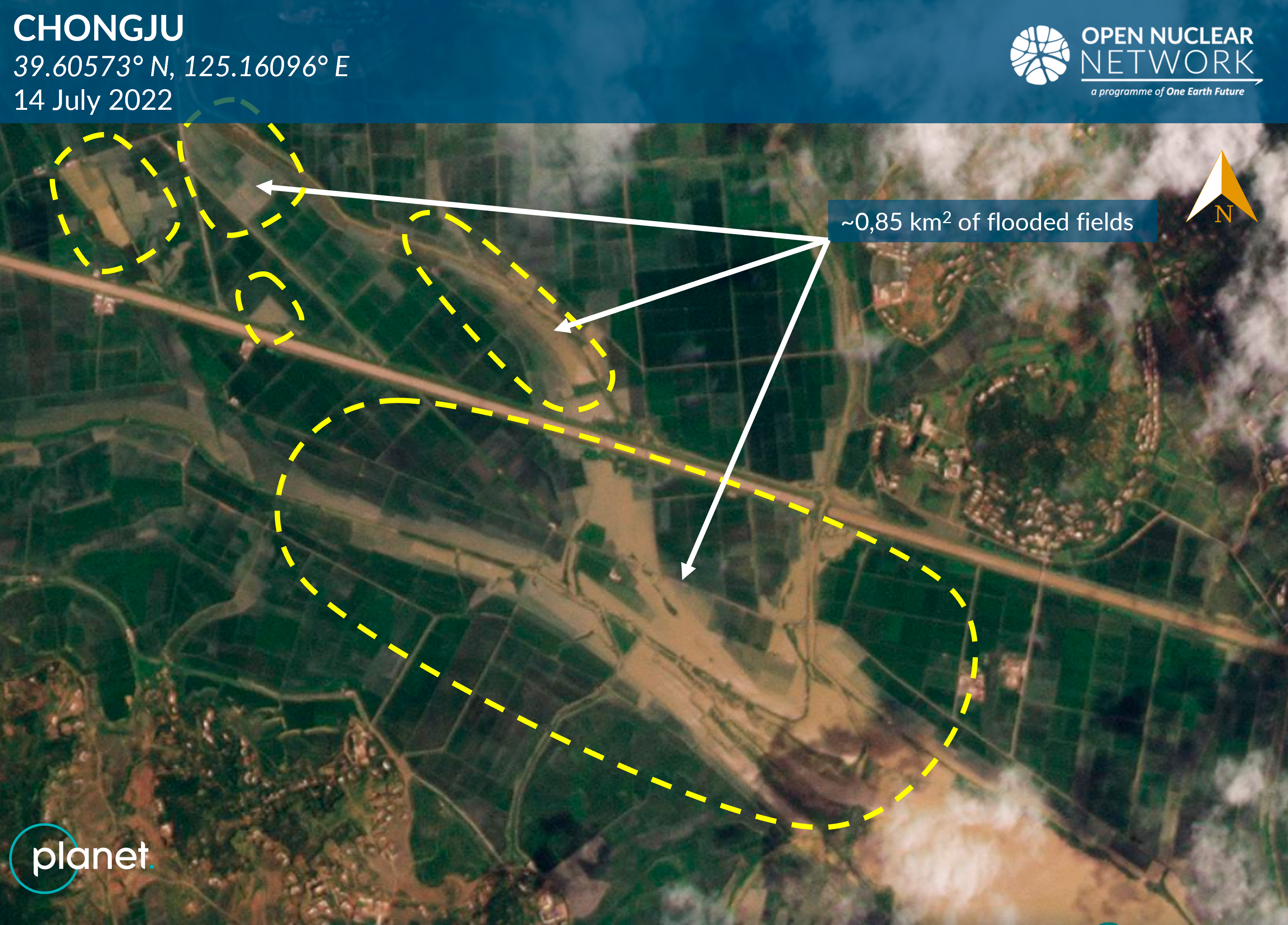
Figure 9. Flooding of agricultural fields near Chongju, North Pyongan province. Image: © 2022 Planet Labs. All rights reserved. Reprinted by permission
North Hwanghae Province
Following the heavy rainfall between 25 and 30 June 2022, flooding over the river crossings was visible on the satellite image from 5 July 2022, indicating that the agricultural fields near these river crossings were also flooded extensively (Figure 10).
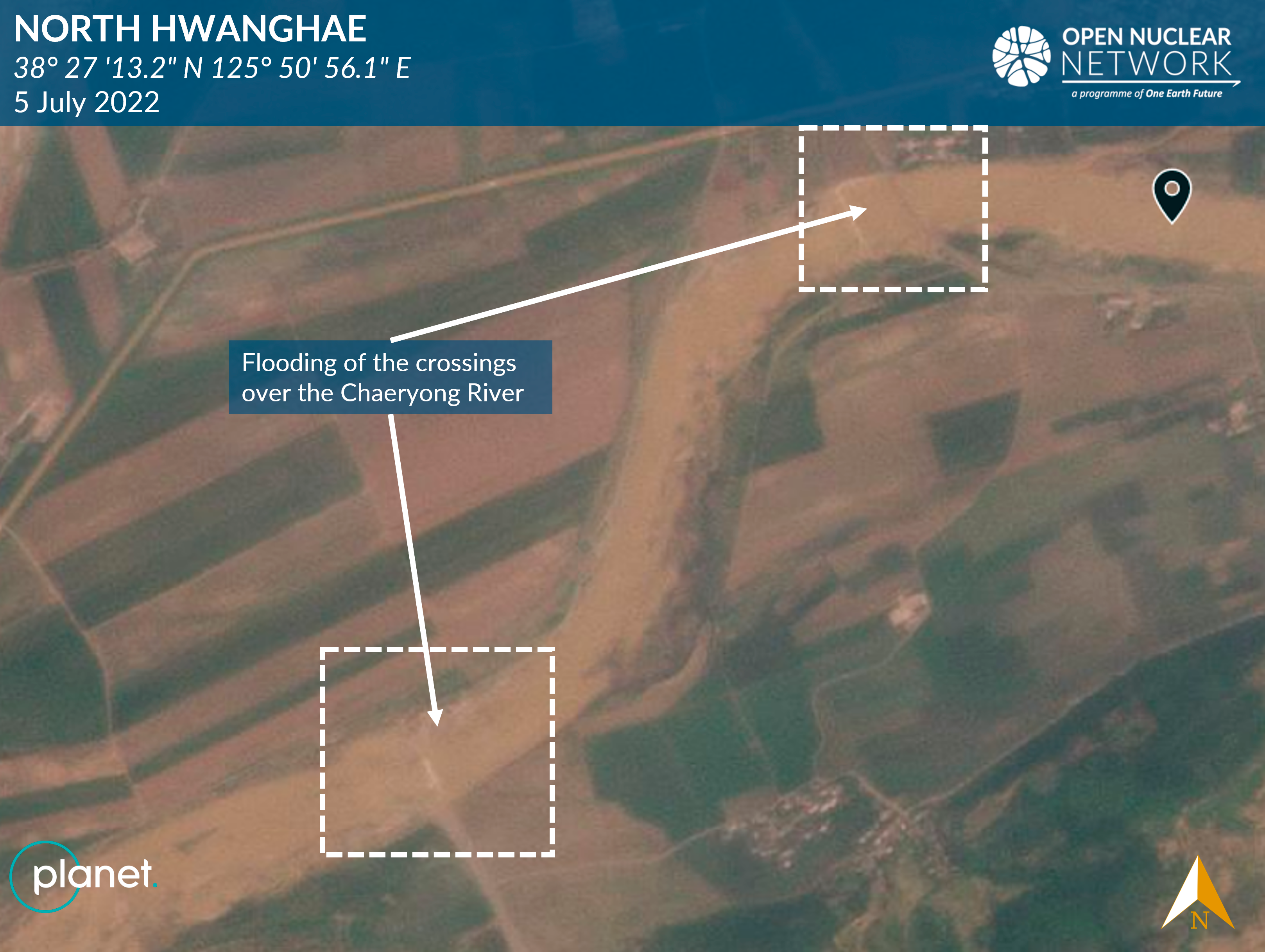
Figure 10. Flooding of crossings over Chaeryong River in Pongsan county, North Hwanghae province. Image: © 2022 Planet Labs. All rights reserved. Reprinted by permission
South Hwanghae Province
The satellite images from 5 and 14 July 2022 show flooded roads and agricultural fields (approximately 2.27 km2) in South Hwanghae province following the heavy rainfall on 25 to 30 June and 13 July 2022 (Figures 12 to 14).
Figure 11. Flooding of agricultural fields in Anak County, South Hwanghae province. Image: © 2022 Planet Labs. All rights reserved. Reprinted by permission
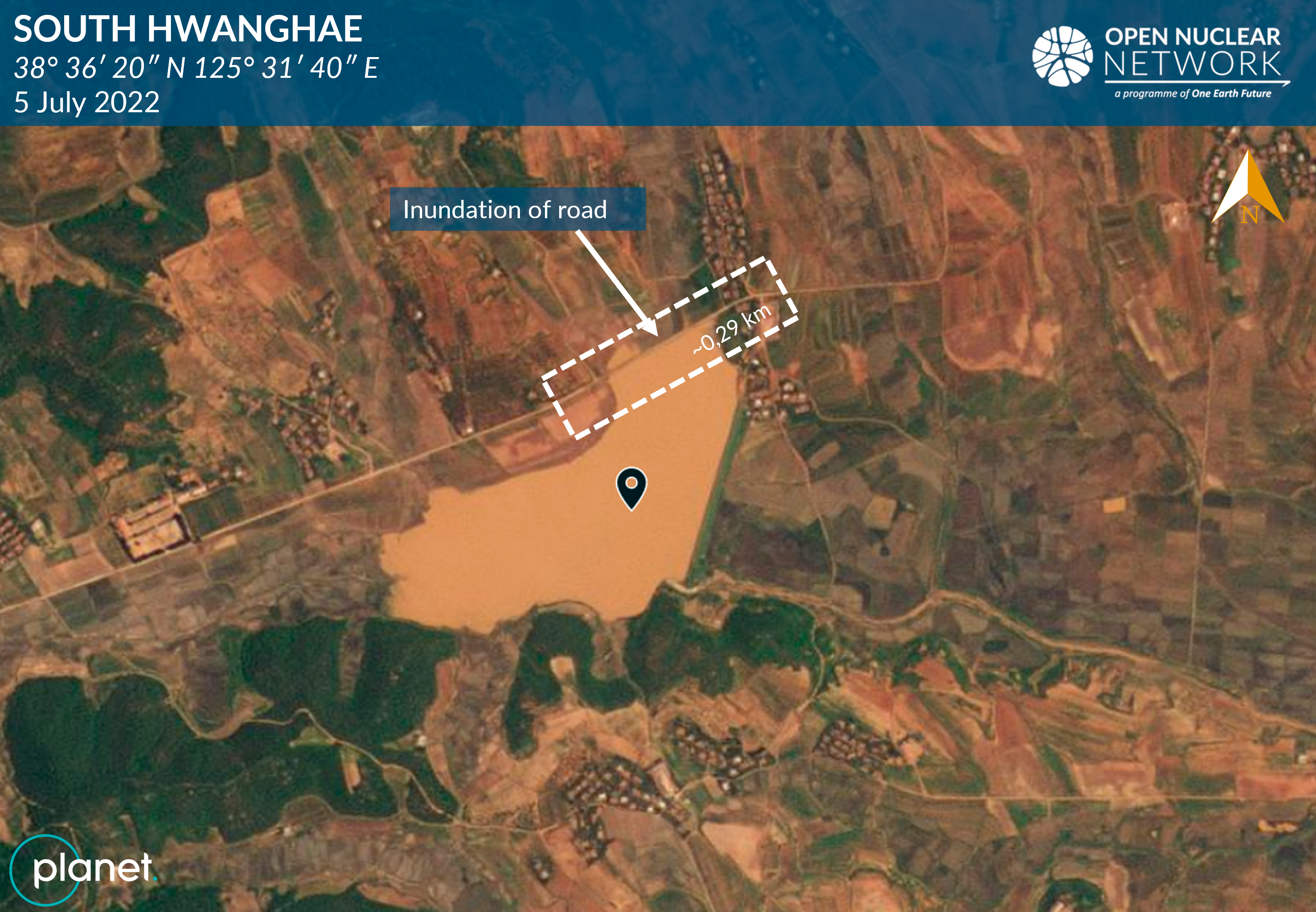
Figure 12. Inundation of road in Unchon county, South Hwanghae province. Image: © 2022 Planet Labs. All rights reserved. Reprinted by permission
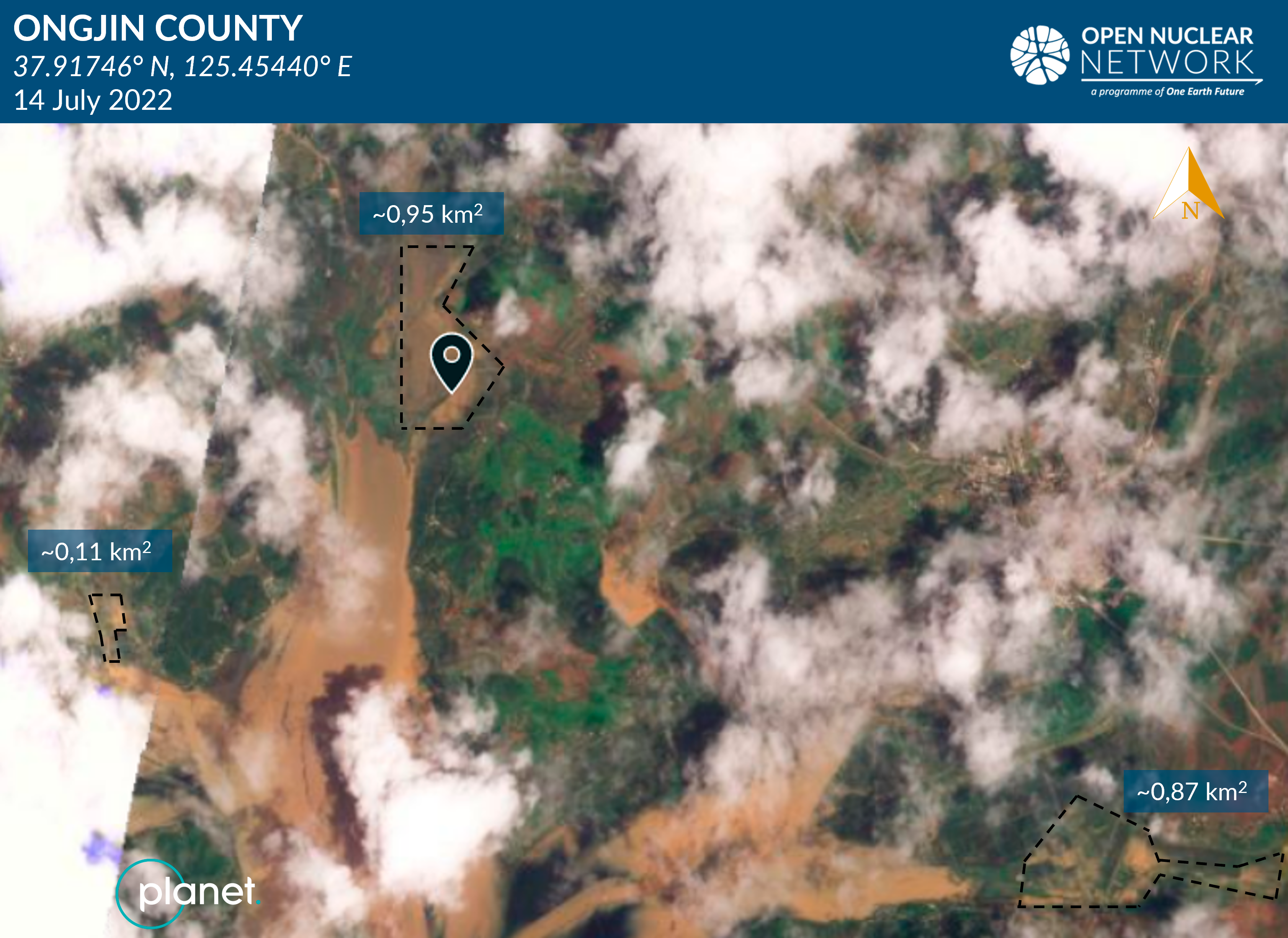
Figure 13. Flooding of agricultural fields in Ongjin county, South Hwanghae province. Image: © 2022 Planet Labs. All rights reserved. Reprinted by permission
Other Areas
Although KCTV focused their reporting mainly on North Pyongan, South Pyongan, North Hwanghae, and South Hwanghae provinces, available satellite images show signs of flooding and possible damage to roads also in South Hamgyong and Kangwon provinces (Figures 15 to 17).
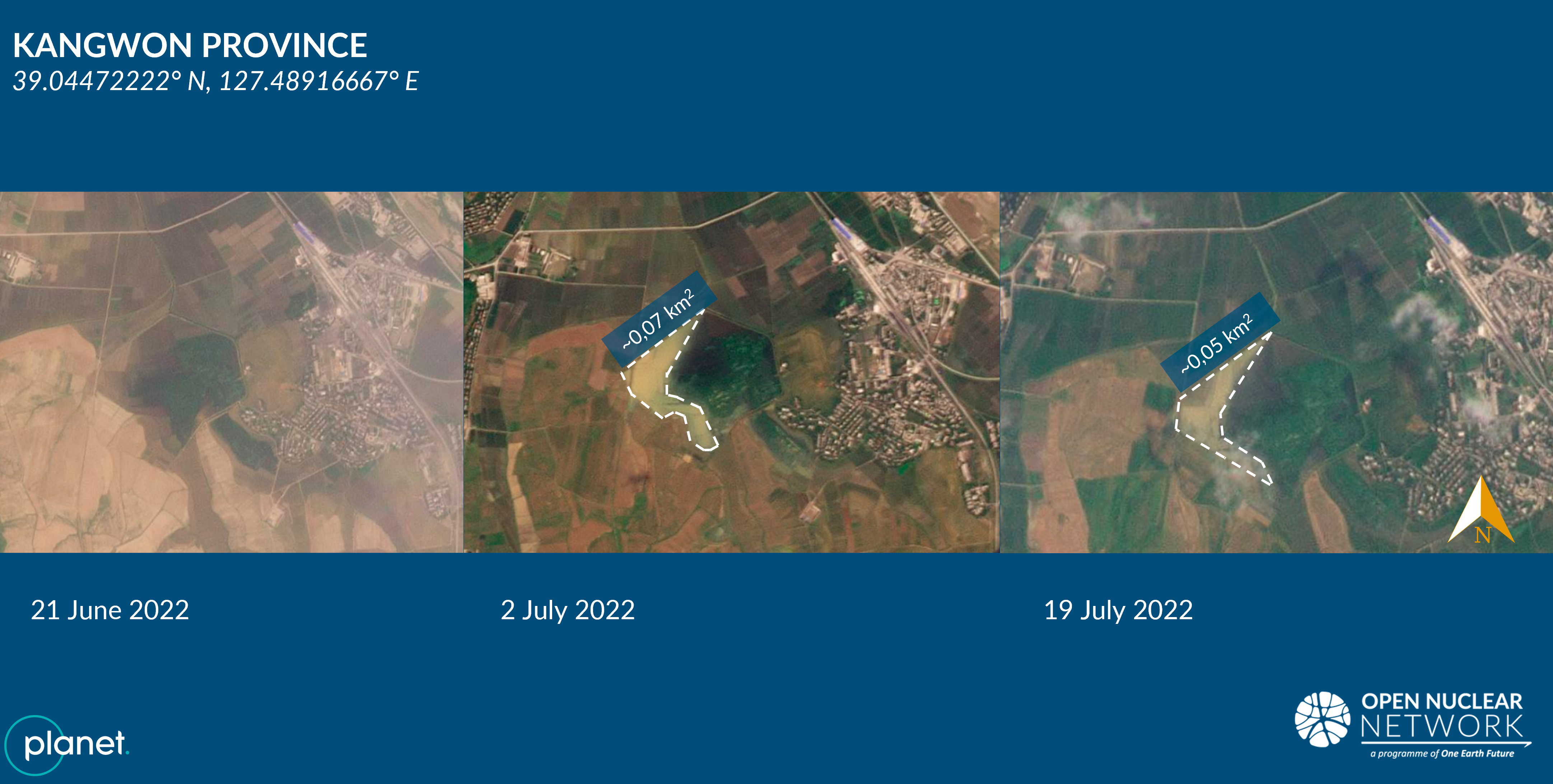
Figure 14. Flooding of an agricultural field in Anbyon county, Kangwon province. Image: © 2022 Planet Labs. All rights reserved. Reprinted by permission
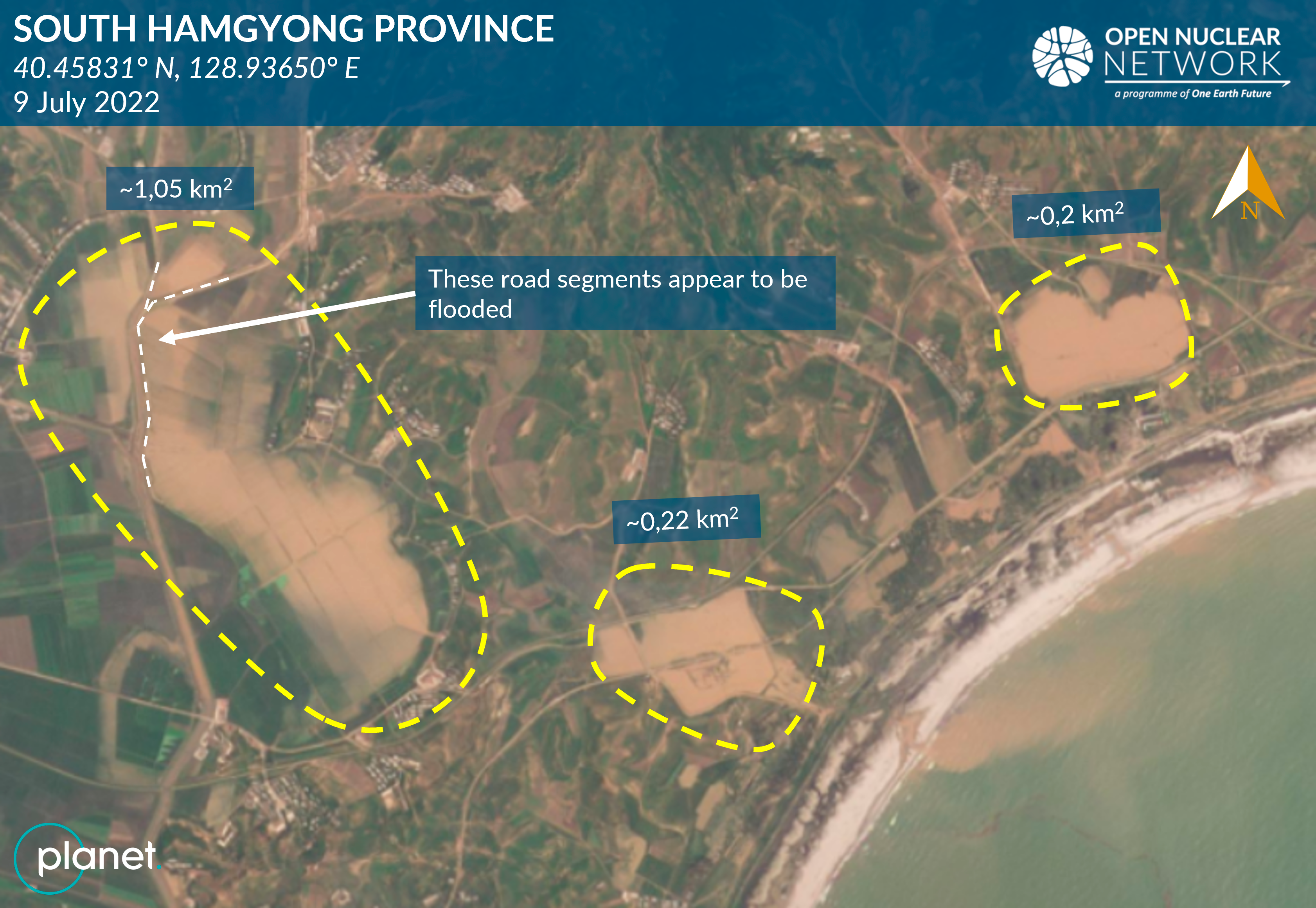
Figure 15. Flooding of agricultural fields and possibly flooded road in Tanchon, South Hamgyong province. Image: © 2022 Planet Labs. All rights reserved. Reprinted by permission
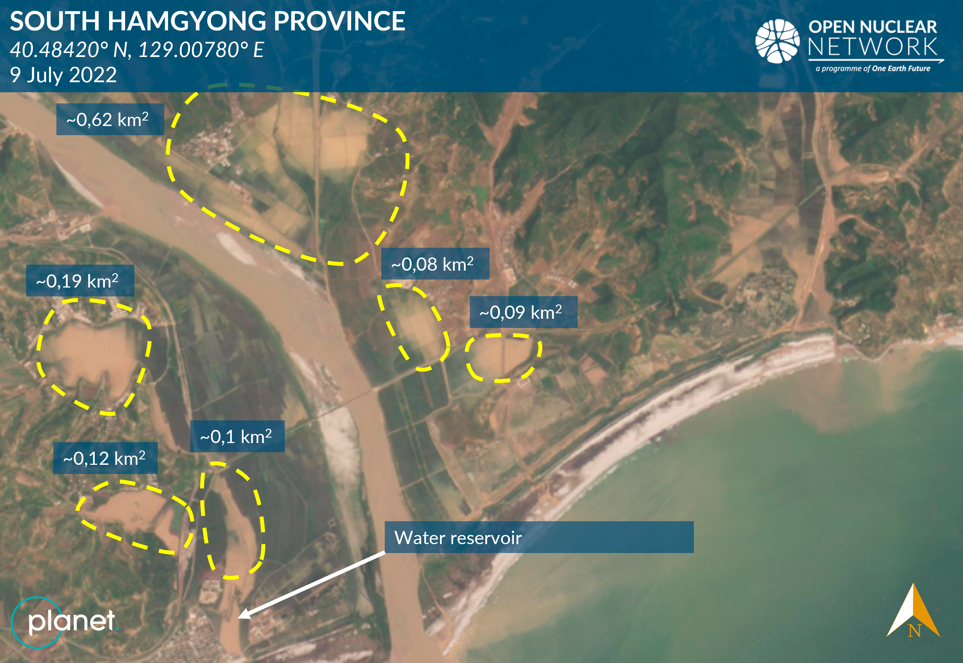
Figure 16. Flooding of agricultural fields in Tanchon, South Hamgyong province. Image: © 2022 Planet Labs. All rights reserved. Reprinted by permission
Water Reservoirs
The water-filled areas in the Kyonryon water reservoirs almost doubled after the heavy rainfall at the end of June 2022 (Figure 17).
Figure 17. Kyonryon water reservoir in Pyongwon county, South Pyongan province. Blue colour - water in the Kyonryon Reservoir (25 June 2022). Red colour - spread of water after rainfalls (5 July 2022). Image: © 2022 Planet Labs. All rights reserved. Reprinted by permission
Impact on Nuclear or Ballistic Missile Programmes
According to 38 North, at the Punggye-ri nuclear test site in North Hamgyong province, repair work on the road leading to Tunnels 2 and 4 appears to have been halted by a landslide, likely caused by the heavy rainfall between late June and mid-July 2022.[18] The tunnels were accessible only on foot as of 27 July 2022.
According to the Center for Strategic and International Studies (CSIS) project Beyond Parallel, increased water levels in the Kuryong River running through the Yongbyon Nuclear Research Centre in North Pyongan province were observed on 3 and 9 July 2022, but no signs of damage to pump houses or other buildings could be identified.[19]
Information available to ONN did not provide any clear signs of damage to other facilities known to be related to the DPRK's nuclear or ballistic missile programmes.
Conclusion
Heavy rainfall and flooding caused damage to several regions in the DPRK at an early stage in the monsoon season. Available satellite images have shown flooded agricultural fields, which are in total a couple of square kilometres greater than the flooded areas identified by ONN following the heavy rainfall in August 2021. However, the scale of reported damage to infrastructure and buildings appears to be much less severe than that observed in August 2020 and 2021.
The rainy season in the DPRK is expected to continue into September 2022. A prolonged period of heavy rainfall and flooding could further weaken the soil, already weakened by drought in spring 2022. These extreme weather conditions could cause further damage to agricultural fields, and may also impact infrastructure and buildings.
In particular, the southwestern regions, which are an important agricultural production base for the country, have been affected. A drought struck these regions between April and June 2022 - a main planting season in which nearly 90% of the annual production of national crops, mainly rice and corn, is planted. Then, heavy rainfall and flooding affected these regions in June and July 2022 - the crop growth season. After the heavy rainfall and flooding in mid-July 2022, the US National Aeronautics and Space Administration (NASA) assessed that the subsurface soil moisture levels - a key factor affecting crop growth - appeared to have stabilised in these regions.[20] However, the damage may have already been done. The extreme weather conditions are expected to impose significant economic and social costs on the DPRK.
The DPRK leadership will likely continue to invest a considerable amount of time and energy in reconstruction, and damage prevention and mitigation until the rainy season finishes in the autumn.
ONN will continue to monitor the impact of heavy rainfall throughout August and September 2022.
[1] Tianran Xu, Katsuhisa Furukawa, Veronika Bedenko, Jaewoo Shin, Assessment of the Impact of August 2021 Rainfall and Flooding in the DPRK, Open Nuclear Network, 13 September 2021, available at: https://opennuclear.org/publication/assessment-impact-august-2021-rainfall-and-flooding-dprk
[2] Peter Makowsky, Jack Liu, Jenny Town, North Korea's Punggye-ri Nuclear Test Site: Continued Infrastructure Development and Flood Damage, 38 North, 4 August 2022, available at: https://www.38north.org/2022/08/north-koreas-punggye-ri-nuclear-test-site-continued-infrastructure-development-and-flood-damage/
[3] The damage from the heavy rainfalls on 30 June 2022 was reported by KCTV on 4 July 2022. 주체 111(2022)년 7월 4일 중앙텔레비죤 [Juche 111 (2022) July 4, KCTV report], KCTV, 4 July 2022, available at: https://kcnawatch.org/kctv-archive/62c2f23f36189/
[4] The 13 monitoring stations are located in Kusong, Supung, Sinuiju (North Pyongan), Nampo, Anju, Yangdok, Pyongyang (South Pyongan), Kaesong, Sariwon, Singye (North Hwanghae) and Haeju, Yongyon (South Hwanghae). In addition, ONN monitored the precipitation levels of the remaining 15 stations in North Korea, located in Wonsan, Chanjon, Pyonggang (Kangwon), Samjiyon, Pungsan, Hyesan (Ryanggang), Kanggye, Chunggang, Huichon (Chagang), Sinpo, Changjin, Hamhung (South Hamgyong), and Kimchaek, Sonbong, Chongjin (North Hamgyong). World Meteorological Organization (WMO), WMO Station Explorer, available at: https://gis.ipad.fas.usda.gov/WmoStationExplorer/
[5] Korea Meteorological Administration (KMA), 북한기상관측, [North Korea Meteorological Observations], available at (in Korean): https://data.kma.go.kr/data/grnd/selectNkRltmList.do?pgmNo=58
[6] Some areas in North Hamgyong Province and Chagang Province also recorded sudden spikes of over 100 mm of daily rainfall between 24 June and 16 July 2022. However, no visible damage could be confirmed through available satellite imagery, and the heavy rainfall in these provinces was not reported by KCTV.
[7] KMA, 북한기상관측 [North Korea Meteorological Observations], available at: https://data.kma.go.kr/data/grnd/selectNkRltmList.do?pgmNo=58; and WMO, WMO Station Explorer, available at: https://gis.ipad.fas.usda.gov/WmoStationExplorer/
[8] KCTV, 30 June 2022, available at: https://kcnawatch.org/kctv-archive/62bdac5a98b7a/
[9] KCTV, 30 June 2022, available at: https://kcnawatch.org/kctv-archive/62bdac5a98b7a/
[10] KCTV, 7 July 2022, available at: https://kcnawatch.org/kctv-archive/62c6e4beb7c99/
[11] KCTV, 13 July 2022, available at: https://kcnawatch.org/kctv-archive/62cecfb939ad3/
[12] KCTV, 13 July 2022, available at: https://kcnawatch.org/kctv-archive/62cecfb939ad3/
[13] KCTV, 4 July 2022, available at: https://kcnawatch.org/kctv-archive/62c2f23f36189/
[14] KCTV, 7 and 13 July 2022, available at: https://kcnawatch.org/kctv-archive/62c6e4beb7c99/ and https://kcnawatch.org/kctv-archive/62cecfb939ad3/
[15] For example, see: Minister Kim Duk-hoon gave a field visit to the Meteorological and Hydrology Bureau and the National Emergency Disaster Committee, Rodong Sinmun, 29 June 2022, available at: http://www.rodong.rep.kp/ko/index.php?strPageID=SF01_02_01&newsID=2022-06-29-0002
[16] KCTV, 21 July 2022, available at: https://www.youtube.com/watch?v=dlc1juDIxwo
[17] KCTV, 21 July 2022, available at: https://www.youtube.com/watch?v=dlc1juDIxwo
[18] Peter Makowsky, Jack Liu, and Jenny Town, North Korea’s Punggye-ri Nuclear Test Site: Continued Infrastructure Development and Flood Damage, 38North, 4 August 2022, available at: https://www.38north.org/2022/08/north-koreas-punggye-ri-nuclear-test-site-continued-infrastructure-development-and-flood-damage/
[19] Joseph S. Bermudez Jr., Victor Cha, and Jennifer Jun, Yongbyon Update: New Activity at Building 500 and Rising Waters, CSIS Beyond Parallel, 11 July 2022, available at: https://beyondparallel.csis.org/yongbyon-update-new-activity-at-building-500-and-rising-waters/
[20] Soil moisture (subsurface) data per province of the DPRK. See: GEOGLAM Crop Monitor and NASA Harvest, Agmet EO Indicators, available at: https://cropmonitor.org/tools/agmet/